Veezer can now be used as a component to visualize a photo from another application and geolocate yourself.
Photo-based geolocation offers an intuitive and engaging approach to mapping. It also provides realistic details and accuracy that are useful for many outdoor activities, complementing the existing content.
Hiking apps, digital topographic maps, adventure route apps, or tourist apps: by using Veezer as a component, photo-based geolocation can be easily integrated to offer an innovative mapping experience in any application.
Example of visualizing a Veezer photo from another application:
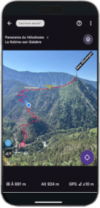
Track your position on a route photo alongside the map in a hiking app, geolocate yourself on a reference photo accompanying the route description in a digital topo app, or locate geocaches on a photo of a natural site during a treasure hunt: the application possibilities are endless!
Photos are prepared in advance using the Veezer app to enable precise geolocation and to overlay tracks and annotations. Then, Veezer can be launched from the third-party app to view the photo and track your position on the image.
This feature is available with the update released on June 22, 2026, for both Android and iOS.